|
Good afternoon, I have just completed a CollectEarth survey and would now like to repeat the survey for a later date. Nothing will change ie. the same sample plots. ...I have tried to find some guidance as to how to manage the files in order to do this best but to no avail. Also - even though I have saved to csv/backup I might choose to return to edit the original survey. Also... I was hoping to start off the second survey with the data from the first survey to speed up assessment where there is no change...and to help clarify what I had classified if there is a jump in the geolocation of the google imagery. Could somebody point me to the appropriate guidance about file management? or provide some guidance here? Thank you very much in advance. Becky |
|
Dear Becky, Thank you for your question, it is a very important one! When DESIGNING a Collect Earth surveyIn this case you can go around this issue by have not one but two unique IDs for the plots. Usually a plot has an attribute "id" that is marked as a key attribute. This means that in the database the plot will be identified uniquely by the value of this attribute. If one is planning to have repeated assessments the best solution is to have a second attribute called for instance "assessment_year" which can be used to identify the assessment phase to which these plots belong. So a plot will be identified by its ID and the year of the assessment. This way in the same survey database you could have the same plot assessed multiple times (once per year per example). This makes later analysis a bit simpler. One tricky thing here is that in the CSV with the plot location you have to add a new column called "assessment_year" next to the id column. This does not fix you problem as you already have the data collected. A POSTERIORIIn your case, the easiest solution would be to create a clone of the survey and import the original data into this clone, then perform the assessment again in the same plots but with this new survey, basically creating two databases in Collect Earth, the old and the new. The data from the old assessment will remain within Collect Earth while a new database for the new cloned survey is generated. You will end up with the old and the new data in two compartments. The analysis of the difference between the database will have to be made through Excel (by exporting to CSV) as Saiku can only show data for one of the databases, not both. First of all, export the data from the old survey as a XML (ZIP). This data will be later imported to the cloned survey.
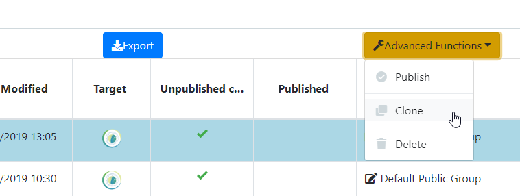
Now you need to clone the olld survey in the Survey Designer. of Open Foris Collect. So for instance you have been working in 2017 with a survey called "survey_one". You will need to clone the survey ( go to the list of surveys and select the survey to be cloned).
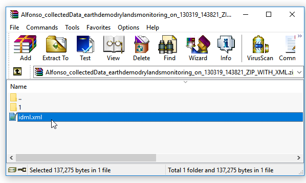
When you clone the survey you can rename it to "survey_two" (or whatever you prefer) . You can now do some slight changes to the survey (remember you can add attributes or modify the labels or the code lists but you shouldn't do any big changes as then it will not be backwards compatible with "survey_one" and you will not be able to import the code ) Now you have to export this new survey as a CEP file (Export to Collect Earth Project ). Click on this new CEP file and Collect Earth will open. Take the ZIP file generated in the first step, open it and edit the file called idml.xml. Change the value of the uri to adapt it to the new survey name. It is the string after the "http://www.openforis.org/idm/earth/" . The URI is the unique identifier of the survey. This identifies where the data contained in the ZIP file belongs. By editing the idml.xml file you are saying that this data "belongs" to the new survey "survey_two" when you import the ZIP file later.
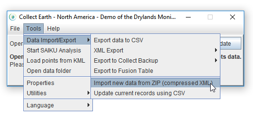
Soooo, now you have a new survey, that is also loaded in Collect Earth, you have a ZIP file with the old data but that is identified with the name of the new survey, the lawst step is to import this ZIP file. Go to Tools->Data Import/Export->Import new data from ZIP (compressed XML)
Select the ZIP file you just edited and once the importing is done you should have the old data in the new survey. You can now reassess the plots and keep the new data separate from the old data...... So when you want to do an analysis of the differences between the plots you will need to export the data as CSV for both databases and work some Excel magic to do that work... Even BETTERWhat if you don't care about having two separate databases. You just want to review if the plots have changed within the two years (say 2017-2019 ).... Then, this is a bit easier. What you want to add is to redo the assessment noting if the area has changed after the first assessment. Edit the survey in the Survey Designer to add a new attribute to it (say for instance "Plot changed 2017-2019" ) then if the user clicks yes, show new attributes that are basically copies from the original.... In the Land Use surveys we usually run we fix this issue by adding a year of Land use change and then adding information about the new land uses in case of change....the possibilities are infinite...maybe you could send a link to a GDrive/Dropbox address to your survey so that we can propose you some changes... Sorry, this post is becoming a bit long now... write back with more info |
|
Wow, this is a great response - thank you. Essentially I have a number of sites that the client would like to understand the change in forest cover over time. This will be achieved through provided land cover change statistics via collectearth. I like the sound of your "even better" idea but wondering if they want to monitor the site every 5 years whether it will be simple enough to analyse the change? if the survey was just repeated each year, analysis of results would be very easy. I will share the survey files over a dropbox... could you advise which ones to share? |
|
Send the CEP file, no need to share the collected data just the survey. This is the link to the drive: https://drive.google.com/drive/u/1/folders/1VAZkMwpzwv3TXCHkokhAGJFf6ejf9GxH Hi There, I have attempted (a few times) the A POSTERIORI method that you mention above - but am failing. If I export the xml and then reload it in the same project - all is fine. However, if, as you suggest - a) make a clone, b) change the idm file, and then c) reload the xml... it doesn't work. we have a set of survey points with no data in them. Might you know what is going array? Thanks Becky |


