|
Hi, We are currently working on reinterpretation of certain points using Collect Earth Desktop and we have external data that we would like to access. This data is available in HTML format and can be accessed as "https://example/plots/plot_id.html". As you can see, the information is fairly simple. However, we are unsure of how to integrate this data with CE or if it is even possible. Could you provide us with some guidance on this? We look forward to your response. Thank you very much. |
|
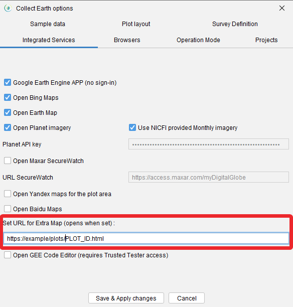
We already have a feature on Collect Earth to handle that functionality. Basically you can connect to URLs using a goal-replacing strategy. In a URL you can use three special "goals" that Collect Earth will use to replace bits of the URL. Example 1 : you have a website where you are linking plots to some visualization using the plot ID (as you describe). You can then use the PLOT_ID goal like this https://example/plots/PLOT_ID.html Example 2 : you have a website or map that you want to show based on the central-location of the CE plot. Then you can use the LATITUDE and LONGITUDE goals. Then you would use a URL like this (using Open Street Map as an example where you pass the zoom level, latitude and longitude) : : https://www.openstreetmap.org/#map=10/LATITUDE/LONGITUDE On a first step you can try the connection with your webpage, then you can modify the survey so that you create a Collect Earth Project (CEP) that already has this connection set up so that you can distribute it to the interpreters that you work with. 1. Test the connection:You can open the Properties dialog then go to Integrated Services and write the URL with the goals described previously on the URL for Extra Map field. After you set up the URL click on Save & Apply and then navigate to a plot in Google Earth (make sure to click on a plot you had not clicked previously). Now a new window with this URL should open.
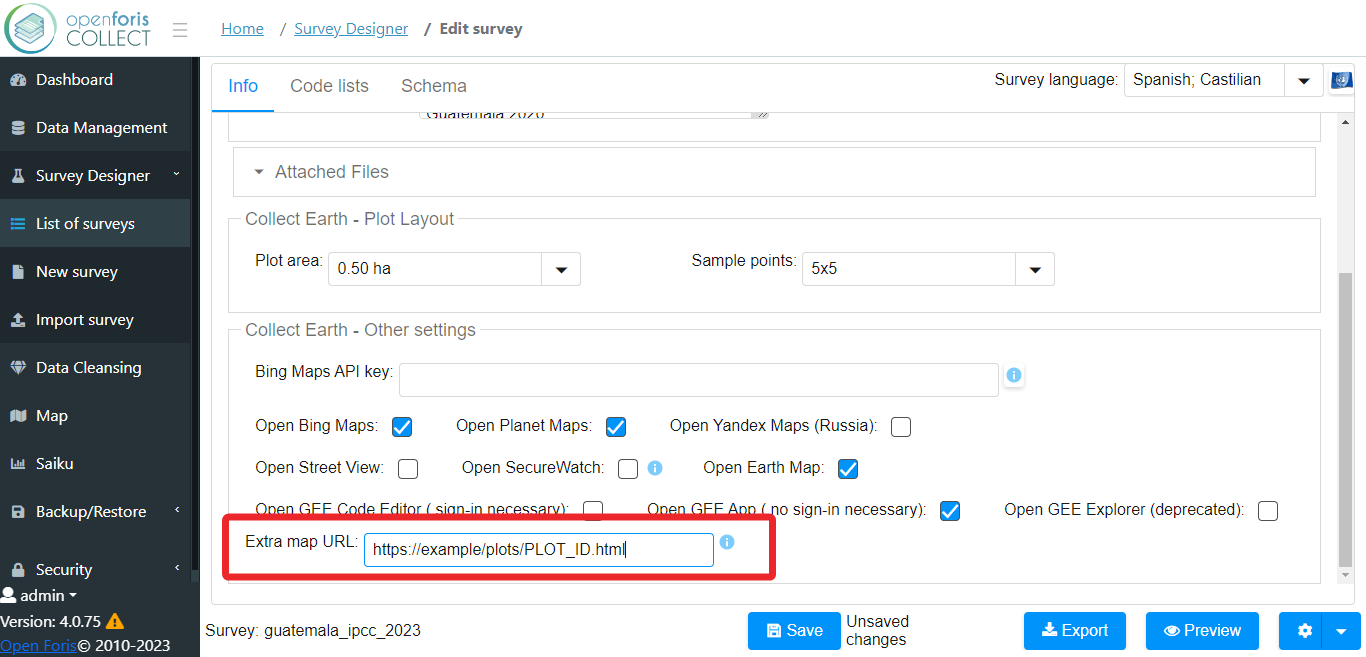
2. Modify the survey:Open Collect Survey Designer. Go to your survey in the Survey Designer section, then in the first tab of the survey editor Info go to Extra map URL in the bottom of that page and put the URL that you have been testing. Save the project, then export to CEP and now anyone that uou send it to will see this new integration.
|
|
Attention, now you can also use the GEOJSON placeholder, which will be automatically susbstituded by the geojson polygon of the plot. So you can also use an extra URL that passes the polygon to something like a GEE App. This is an example of how to use it https://collectearth.projects.earthengine.app/view/plotversion2025#geoJson=GEOJSON;plotId=PLOT_ID; This GEE App with this code expects the GEOJSON and plotId parameters to generate the GEE charts and map visualizations |