Hi Kanchana!
How to use arbitrary polygons instead of the Collect Earth standard shapes for plots ( square, hexagon, NFI cluster, etc... )
The answer to this is a bit long.
YOU CAN DO IT! Yes, it is not super simple but lets start:
- Imagine you have a super simple survey with only one attribute. This is an example : CEP for Super Simple survey.
- Normally, the plot locations in Collect Earth are determined by the location attribute ( a required attribute of type coordinate that in the CSV of the plots is edited using the YCoordinate and XCoordinate columns )
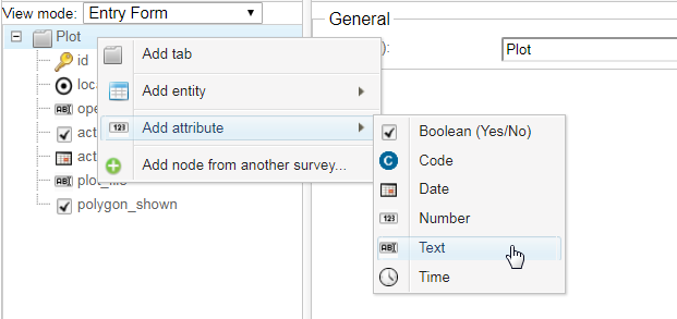
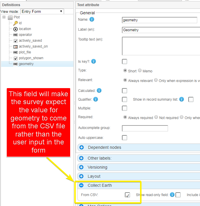
- If you want to use polygons instead you need to add a new text attribute (let us call it geometry), make sure that in the Collect Earth options you set is as "Coming from CSV"


So if in the first version of the survey you have a grid file that looks like this :
id,"YCoordinate","XCoordinate"
id_1,-4.998422,151.358785
id_2,-5.597393,150.467849
id_3,-5.764004,148.440329
id_4,-4.67945,149.436835
id_5,-4.945604,151.35277
In the second version of the survey the CSV that is used should look like this:
id,Ycoordinate,Xcoordinate,geometry
POLYGON_1,0,0,<Polygon><outerBoundaryIs><LinearRing><coordinates> .... </coordinates></LinearRing></outerBoundaryIs></Polygon>
POLYGON_2,0,0,<Polygon><outerBoundaryIs><LinearRing><coordinates> .... </coordinates></LinearRing></outerBoundaryIs></Polygon>
POLYGON_3,0,0,<Polygon><outerBoundaryIs><LinearRing><coordinates> .... </coordinates></LinearRing></outerBoundaryIs></Polygon>
POLYGON_4,0,0,<Polygon><outerBoundaryIs><LinearRing><coordinates> .... </coordinates></LinearRing></outerBoundaryIs></Polygon>
SO, the easiest process to get the KML polygons from a shapefile follow these steps :
- Open the Shapefile in QGis.
- Export the layer as a KML file
- Go to Google Drive and create a new Fusion tables. Upload the KML file that you generated from QGis.
- Once the import process is finished download the Fusion table and choose the CSV format. When you do this you get a CSV file where there is a column with the shape as a KML polygon.
- Take that column and use it to generate the actual format expected by Collect Earth
Google Fusion tables are being deprecated soon. Right now we are working on hte possibility to import a shapefile directly into Collect Earth. Using the DBF file (attribute table) as the input for the ID and so on and the shape as the geometry. More on this on the coming weeks.
IF YOU WANT TO HAVE SAMPLING DOTS!
The easiest solution is to include the sampling dots inside the shapes of the polygon (then they would become a multipolygon) and then use the previously written methodology to use in the CSV.
answered
21 Nov '19, 11:46

Open Foris ♦♦
1.1k●5●7●14
accept rate:
10%


Dear OF, is it also possible to sample polygons at cluster level in Collect/Collect mobile as described below (for Collect Earth): 1) adding a text/geometry attribute, with data coming from CSV, and 2) shape file location information (now fusion tables are discontinued)? Joseph